فائل:Indus.A2002274.0610.1km.jpg
اس نمائش کا حجم: 458 × 599 پکسلز۔ دیگر تصمیمات: 183 × 240 پکسلز | 367 × 480 پکسلز | 587 × 768 پکسلز | 783 × 1,024 پکسلز | 1,300 × 1,700 پکسلز۔
اصل فائل (1,300 × 1,700 پکسل، فائل کا حجم: 480 کلوبائٹ، MIME قسم: image/jpeg)
خلاصہ
| تفصیل |
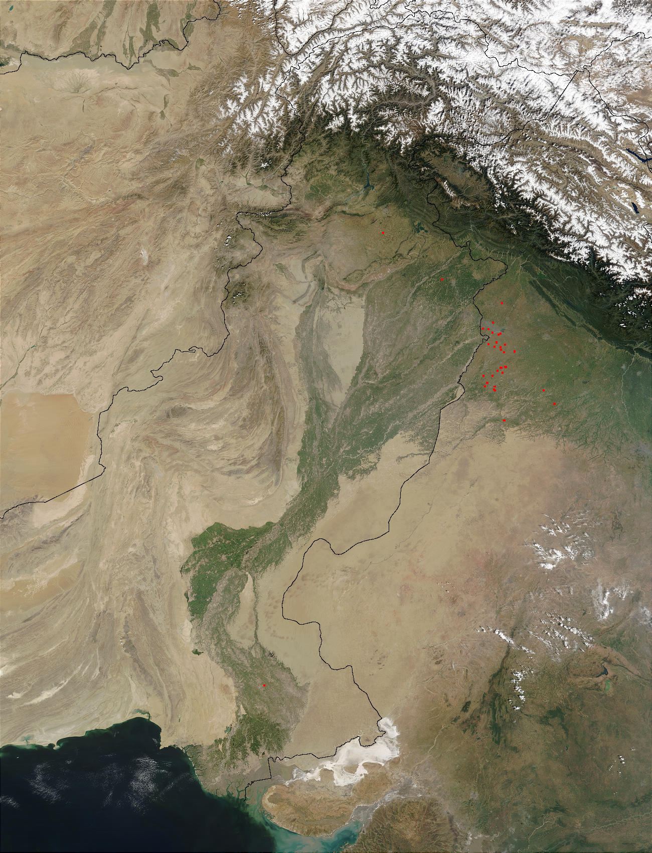
English: en:Satellite image of the en:Indus River basin. Red dots indicate fires. International boundaries are superimposed; the boundary through en:Jammu and Kashmir reflects the en:Line of Control. Agricultural burning is occurring in Northwest India (usually at right) and Pakistan (at left )near the Indus River in October 2002. The Moderate Resolution Imaging Spectroradiometer on the Aqua satellite detected numerous fires (red dots) burning just east of India’s border with Pakistan (upper left quadrant). The haze in the area is probably not solely due to the fires, however; some of it is likely urban air pollution from several large cities in the region. In the upper right quadrant, the foothills of the Himalayas are deep green, and the peaks are dusted with snow and capped by clouds. |
| ماخذ | visibleearth.nasa.gov/view.php?id=62558 |
| مصنف | Credit: Jacques Descloitres, MODIS Rapid Response Team, NASA/GSFC |
اجازہ کاری
| This file is in the public domain in the United States because it was solely created by NASA. NASA copyright policy states that "NASA material is not protected by copyright unless noted". (See Template:PD-USGov, NASA copyright policy page or JPL Image Use Policy.) | ||
 |
Warnings:
|
اولین اپلوڈ کا نوشتہ
فائل کی تفصیلات کا اصل صفحہ یہاں تھا۔ درج ذیل تمام صارفین en.wikipedia کے ہیں۔
- 2005-08-16 16:29 Tom Radulovich 1300×1700×8 (491377 bytes) {{PD-USGov-NASA}}
فائل کا تاریخچہ
کسی خاص وقت یا تاریخ میں یہ فائل کیسی نظر آتی تھی، اسے دیکھنے کے لیے اس وقت/تاریخ پر کلک کریں۔
| تاریخ/وقت | تھمب نیل | ابعاد | صارف | تبصرہ | |
|---|---|---|---|---|---|
| رائج الوقت | 13:03، 28 مارچ 2008ء | | 1,300 × 1,700 (480 کلوبائٹ) | File Upload Bot (Magnus Manske) | {{BotMoveToCommons|en.wikipedia}} {{Information |Description={{en|en:Satellite image of the en:Indus River basin. Red dots indicate fires. International boundaries are superimposed; the boundary through en:Jammu and Kashmir reflects the [[ |
روابط
درج ذیل 3 صفحات اس فائل کو استعمال کر رہے ہیں:
فائل کا عالمی استعمال
مندرجہ ذیل ویکیوں میں یہ فائل زیر استعمال ہے:
- af.wiki.x.io پر استعمال
- ar.wiki.x.io پر استعمال
- arz.wiki.x.io پر استعمال
- ast.wiki.x.io پر استعمال
- as.wiki.x.io پر استعمال
- azb.wiki.x.io پر استعمال
- az.wiki.x.io پر استعمال
- ba.wiki.x.io پر استعمال
- be-tarask.wiki.x.io پر استعمال
- bh.wiki.x.io پر استعمال
- bn.wiki.x.io پر استعمال
- bo.wiki.x.io پر استعمال
- br.wiki.x.io پر استعمال
- bs.wiki.x.io پر استعمال
- bxr.wiki.x.io پر استعمال
- ca.wiki.x.io پر استعمال
- ceb.wiki.x.io پر استعمال
- ce.wiki.x.io پر استعمال
- ckb.wiki.x.io پر استعمال
- cy.wiki.x.io پر استعمال
- da.wiki.x.io پر استعمال
- en.wiki.x.io پر استعمال
- en.wiktionary.org پر استعمال
- eo.wiki.x.io پر استعمال
- es.wiki.x.io پر استعمال
- eu.wiki.x.io پر استعمال
- fa.wiki.x.io پر استعمال
- fiu-vro.wiki.x.io پر استعمال
- gd.wiki.x.io پر استعمال
- gl.wiki.x.io پر استعمال
- he.wiki.x.io پر استعمال
- hi.wiki.x.io پر استعمال
- hy.wiki.x.io پر استعمال
- ia.wiki.x.io پر استعمال
- id.wiki.x.io پر استعمال
اس فائل کا مزید عالمی استعمال دیکھیے۔