فائل:Periplous of the Erythraean Sea.svg

اس SVG فائل کی PNG نمائش کا حجم: 800 × 564 پکسلز دیگر تصمیمات: 320 × 226 پکسلز | 640 × 452 پکسلز | 1,024 × 722 پکسلز | 1,280 × 903 پکسلز | 2,560 × 1,806 پکسلز۔
اصل فائل (ایس وی جی فائل، ابعاد 1,280 × 903 پکسل، فائل کا حجم: 1.39 MB)
خلاصہ
| تفصیل |
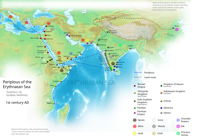
English: Periplous of the Erythreaen Sea map, according to the description from source text (https://el.wikisource.org/wiki/Περίπλους_τῆς_Ἐρυθράς_Θαλάσσης). Original names have been transcribed to Latin alphabet when possible. For the Greek names look at the respective Greek version of the map.
Ελληνικά: Χάρτης του περίπλου της Ερυθράς Θαλάσσης(Αγγλική έκδοση), σύμφωνα με την περιγραφή του κειμένου (https://el.wikisource.org/wiki/Περίπλους_τῆς_Ἐρυθράς_Θαλάσσης). हिन्दी: एरिथ्रेअन सागर के पेरिप्लस के नाम, मार्ग और स्थान
Català: Mapa del Periple de la Mar Eritrea, segons la descripció de la font (https://el.wikisource.org/wiki/Περίπλους_τῆς_Ἐρυθράς_Θαλάσσης). Els noms originals s'han transcrit a l'alfabet llatí quan ha estat possible. Per als noms grecs mireu la versió grega del mapa. |
| تاریخ | |
| ماخذ | ذاتی کام |
| مصنف | George Tsiagalakis |
| اجازت (فائل کا دوبارہ استعمال) |
Mention author and licence when using this work, e.g. "George Tsiagalakis / CC-BY-SA-4 licence" |
| دوسرے نسخے |
|


This W3C-unspecified vector image was created with Inkscape .

|
یہ ایس وی جی (SVG) فائل نصب شدہ متن (ایمبیڈڈ ٹیکسٹ) پر مشتمل ہے، جسے کسی بھی SVG ایڈیٹر یا ٹیکسٹ ایڈیٹر کا استعمال کرتے ہوئے یا SVG آلہ ترجمہ کی معاونت سے آپ کی زبان میں ترجمہ کیا جا سکتا ہے۔ مزید معلومات کے لیے دیکھیے: SVG فائلوں کا ترجمہ۔ |
اجازہ کاری
میں اس تخلیقی کام کے حقوق کا مالک ہوں اور اسے مندرجہ ذیل اجازت نامے کے تحت شائع کرتا ہوں:
| Multi-licensed with all versions of the Creative Commons Attribution Share-Alike License | ||
| I agree to multi-license my contributions, unless otherwise stated, under the GFDL and the Creative Commons Attribution Share-Alike license version 1.0, version 2.0, version 2.5, version 3.0, and all future versions of the Creative Commons Attribution Share-Alike license. Please be aware that other contributors might not do the same, so if you want to use my contributions under the Creative Commons terms, please check the CC dual-license and Multi-licensing guides. | ||

|
آپ کو آزاد سافٹ ویئر فاؤنڈیشن کی جانب سے شائع کردہ جی این یو آزاد مسوداتی اجازت نامہ کی شرائط استعمال کے تحت اس دستاویز کو نقل، تقسیم اور/ یا ترمیم کرنے کی اجازت دی جاتی ہے۔ اس اجازت نامہ کی ایک نقل 'جی این یو آزاد مسوداتی اجازت نامہ کے عنوان سے میسر ہے۔ |
This file is licensed under the Creative Commons Attribution-Share Alike 4.0 International, 3.0 Unported, 2.5 Generic, 2.0 Generic and 1.0 Generic license.
- آپ آزاد ہیں:
- شیئر کرنے – کام کو نقل، تقسیم یا منتقل کرنے کے لیے
- ریمکس کے لیے – کام منبطق کرنے کے لیے
- مندرجہ ذیل شرائط کے تحت:
- انتساب – آپ کو اس کام کا انتساب مصنف یا اجازت دہندہ کے بتائے گئے طریقہ کے مطابق دینا ہوگا (تاہم یہ انتساب اس طرح نہیں ہونا چاہیے کہ اسے دیکھ کر ایسا محسوس ہو کہ اصل مصنف یا اجازت دہندہ آپ کے یا آپ کے ذریعہ اس کام کے استعمال کرنے کے حامی ہیں)۔
- یکساں شراکت – اگر آپ اس کام میں کوئی تبدیلی یا ترمیم کرتے ہیں یا اس کام پر مبنی کچھ نیا بناتے ہیں تو اسے بھی آپ اسی یا اس جیسے کسی اجازت نامے کے تحت شائع کر سکتے ہیں۔
فائل کا تاریخچہ
کسی خاص وقت یا تاریخ میں یہ فائل کیسی نظر آتی تھی، اسے دیکھنے کے لیے اس وقت/تاریخ پر کلک کریں۔
| تاریخ/وقت | تھمب نیل | ابعاد | صارف | تبصرہ | |
|---|---|---|---|---|---|
| رائج الوقت | 17:48، 29 ستمبر 2023ء | | 1,280 × 903 (1.39 MB) | Joutbis | File uploaded using svgtranslate tool (https://svgtranslate.toolforge.org/). Added translation for ca. |
| 17:33، 29 ستمبر 2023ء |  | 1,280 × 903 (1.38 MB) | Joutbis | File uploaded using svgtranslate tool (https://svgtranslate.toolforge.org/). Added translation for ca. | |
| 21:13، 1 فروری 2023ء |  | 1,280 × 903 (1.32 MB) | Theklan | File uploaded using svgtranslate tool (https://svgtranslate.toolforge.org/). Added translation for eu. | |
| 19:12، 9 جنوری 2022ء |  | 1,280 × 903 (1.28 MB) | Mr. Ibrahem | Reverted to version as of 11:44, 6 May 2021 (UTC) | |
| 13:29، 9 جنوری 2022ء |  | 1,280 × 903 (1.28 MB) | Mr. Ibrahem | File uploaded using svgtranslate tool (https://svgtranslate.toolforge.org/). Added translation for ar. | |
| 11:44، 6 مئی 2021ء |  | 1,280 × 903 (1.28 MB) | Andrei Stroe | File uploaded using svgtranslate tool (https://svgtranslate.toolforge.org/). Added translation for ro. | |
| 16:10، 31 جنوری 2015ء |  | 1,280 × 903 (1.28 MB) | Gts-tg | Small updates in spelling of city names | |
| 15:39، 31 جنوری 2015ء |  | 1,280 × 903 (1.28 MB) | Gts-tg | More accurate positioning for Nikon(os) and Sarapion(os), corresponding to modern Barawe and Mogadishu respectively. Improved legibility of place names | |
| 03:15، 29 جنوری 2015ء |  | 1,280 × 903 (1.28 MB) | Gts-tg | Updates as [https://en.wiki.x.io/wiki/User_talk:Gts-tg#Periplus_svg indicated by Wikipedia editors] | |
| 17:31، 26 دسمبر 2014ء |  | 1,280 × 903 (1.28 MB) | Gts-tg | User created page with UploadWizard |
روابط
درج ذیل 2 صفحات اس فائل کو استعمال کر رہے ہیں:
فائل کا عالمی استعمال
مندرجہ ذیل ویکیوں میں یہ فائل زیر استعمال ہے:
- af.wiki.x.io پر استعمال
- ar.wiki.x.io پر استعمال
- arz.wiki.x.io پر استعمال
- az.wiki.x.io پر استعمال
- bg.wiki.x.io پر استعمال
- bn.wiki.x.io پر استعمال
- ca.wiki.x.io پر استعمال
- ceb.wiki.x.io پر استعمال
- cs.wiki.x.io پر استعمال
- da.wiki.x.io پر استعمال
- de.wiki.x.io پر استعمال
- el.wiki.x.io پر استعمال
- en.wiki.x.io پر استعمال
اس فائل کا مزید عالمی استعمال دیکھیے۔